
 Croobyar Road Catchment
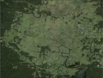
Croobyar Road catchment
The Croobyar Road catchment covers an approximate area of 2,200ha (agricultural land) and includes the important riparian corridors of Croobyar, Leaneys and Stoney Creeks. These three sub-catchments support the regionally significant Narrawallee Inlet and Burrill Lake Estuary systems. The catchment is predominately cleared farming land dominated by beef, sheep, small lifestyle properties and a large intensive dairy farm.
History of the Croobyar Road catchment
The Small Farms Network has been working with members across the Croobyar Road catchment since 2004, providing training in sustainable land management, soil testing, workshops and NRM projects. Since 2010, the Network has received three funding grants to support a number of key land management targets. These include:
1. Establish a series of vegetation corridors across the landscape, linking remnant Forest Red Gum and Riparian vegetation, providing shade for livestock and a weed trap for fireweed.
2. Protect and enhance riparian corridors within the catchment
3. Protect and enhance NSW EEC - Milton Ulladulla Sub-Tropical Rainforest remnants
4. Improve sustainable land management through regular education, soil testing and fertiliser management plans, dung beetle releases, pasture and weed management.
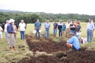 Monzonite Soils Day 2011
Community Action Grant 2010 - Improving soil health and revegetating the Milton Monzonite
This project was the result of an informal (cuppa & cake) meeting with 25 local landholders about sustainable farming issues in Spring 2010. Funding was sought and received by the Small Farms Network through the Community Action Grant program. This project included:
* 23 soil tests taken over 8 farms with a fertiliser management report completed by NSW DPI Agronomist
* A Monzonite Soils Day was held with 31 people attending. The day included a discussion about the soil test results, a soil pit excavation and fertiliser and management options for the monzonite soil
* 4,000 Geotrupes spiniger and 3,000 Bubas bison dung beetles were released across seven properties across the Croobyar catchment
* Six NRM projects were funded which included the establishment of 2.1km of shelterbelts (2,000 tubestock) and 680m of riparian fencing and 300 tubestock planted.
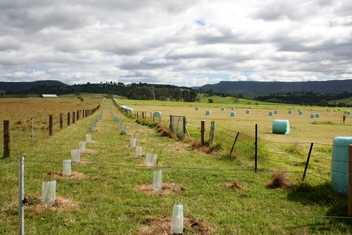 880m shelterbelt on Bonnie View Drive
Milton Rocks! Building a Sustainable Monzonite Landscape (Caring for our Country 2012-13)
Milton Rocks project funded 27 projects on 14 farms and engaged 22 landholders who manage 60% of the agricultural land within the catchment area.
This project:
* Established 6.44km (5.7ha) of vegetation corridors across cleared farming land
* Protected and revegetated 3.33km (9.76ha) of riparian corridors
* Planted over 11,100 tubestock
* Installed 1.4km of off stream watering pipe & 6 water troughs
* Realeased 8,000 winter active dung beetles
* Conducted 34 soil tests across 12 farms
* Organised 4 training events which focussed on pasture, grazing and livestock management - attended by 104 landholders.
Click here for a copy of the Project Case Study or view the various project sites below.
